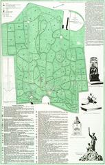
Lychakiv Cemetery. Scheme
- ID: 34568
- Place: Lviv


This map was printed to familiarize people with the recently renamed streets and squares of Lviv.
The map is dated 1877. The publisher is the Karol Wild Bookstore of Lviv; it was lithographed and printed by Kornell Piller Printers (Nakładem Karola Wilda. Lit i druk Kornella Pillera). This reprint includes a list of old and new street and square names (Plan kr. st. m. Lwowa ze skorowidzem dawnych i nowych nazw placów i ulic we Lwowie); it was originally printed in 1871 and first reprinted in 1872.
Karol Wild’s Bookstore "Buch und Musikalienhandlung", established in 1796, was initially located on Virmenska Street. The bookseller sold books, notes, office supplies, haberdashery, musical instruments, art work and wallpaper.
In 1810 Wild began publishing; a year later he opened the Public book lending establishment (Привілейована Публічна випозичальня книжок). In 1834 Wild’s son-in-law Edward Vinyazh took over the bookstore. In 1849 Karol Wild, Jr. (1824-1885) became the proprietor of the bookstore and lending establishment. When the map was published in 1877 the bookstore was located at Halytska Street, 21.
In 1881 the bookstore went bankrupt and the 20 000 book lending establishment was sold to Vladyslav Hubrynovych; Karol Wild, Jr. continued to run the establishment for another couple of years for the new owner. [33], p. 40-49
The unique graphic feature of this map is that pavilions from the First National Agricultural Industrial Exhibition (Wystawa Przemyslowo rolnicza) are shown.
Legend:
Map Characteristics:
Map’s Toponymics:
The legend contains information about 65 objects; another 284 are labeled directly on the map:Inconsistencies and inaccuracies on the map:
Characterization of the city:
On 14 December 1870 the charter giving Lviv Royal Capital City status was approved; this signaled the beginning of an era of autonomy in the city’s management.
In 1871 a resolution was adopted which ordered street names to be changed and the city to be divided into 5 districts. All buildings were re-numbered; odd numbered buildings appeared on the left hand side of the street and even numbers on the right. [31], p. 333
As a result of these changes the Karol Wild bookstore started distributing maps of the city with a list of old and new street and square names. These maps would have been in great demand as they were printed in 1871, 1872 and 1877. [12], p. 237-238
The map shows the result of the intensified building campaign that started in the early 1870s. Among the most important changes in the city’s landscape are:
The pavilion of the First Regional Agriculture and Industry Exhibition which ran from 6 September through 10 October 1877 on the territory of the Yablonovsky Orchards is visible on the map. The exhibition was an important event in developing an industrial sector in Galicia. [31], p. 152-153, 715
As of 1877 there were 106 379 residents in the city including 6,224 military personnel. [34], p. 114 Records also show that in 1876 Lviv had 105 community associations with 26 678 registered members. [71], p. 119
In 1877 there were 2 942 residential buildings containing 22 532 individual living quarters. At this time the city’s growth was due to development of the suburbs. [34], p. 61, 63
In 1874-1876 there were 222 new buildings built and 285 permits issued for additions and alterations to existing buildings.
Author: Serhii Tereshchenko