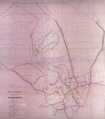
Regulation Plan of the Truskawiec Resort
- ID: 34458
- Place: Truskavets


This map of Truskawiec was published in 1933, as a supplement to an illustrated guide to the resort and its surroundings [62].
The plan shows the extent of constuction in the city, from the central part, to the surrounding territories. The network of main streets was almost fully formed at this point [60], p. 63.
The map was printed at K. Rogalski's Lithography and Printing House.
Legend:
Map characterization:
Map toponymics:
The map includes a list of 459 toponyms.
Inconsistencies and inaccuracies on the map:
City characterization:
In 1911 Truskavets became the property of the "Truskavets Streams" Joint Stock Company, headed by Rajmund Jarosz. Construction of a power plant, and the introduction of the railway became key factors in the resort's development in early twentieth century. In the 1920s and 1930s much attention was given to increasing the town's greenery (the town was decorated with flower-beds and exotic plants), and improving the infrastructure for those taking their cures at the resort [62] p. 12.
According to the December 1931 census, the town's population comprised 3,012 people. As of 1931, Truskavets had around 4,000 rooms for arrivals. During this period, the resort was visited by over 14,000 people annually [62] p. 16.
The map shows the extant and projected construction, which allows the conclusion that over 70 per cent of the town's buildings were residential. Public buildings were usually located in the central part of Truskavets, along today's Drohobycha (then Łazienna), Bandery (then Główna Zdrojowa), Shevchenka, and Ob'yiznoyi (Objazdowa) streets. Construction began to go beyond the limits of the town center, and include today Drohobytska, Sukhovoli, Franka, Pomiretska, and Stebnytska streets [60], p. 63.
Entry by: Khrystyna Kharchuk Translated by: Pavlo Hrytsak


