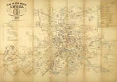
A map of the city of Lviv from 1917 with districts and neighbourhoods demarcated.
The map was created by the Measurement-Regulation Office of the city’s Technical Department.
Legend:
- In the upper right corner is the name “Map of the Royal Capital City Lviv” (Mapa król. stoł. miasta Lwowa).
- Beneath the name is information on the creator: “Created by the Measurement-Regulation Office of the Technical Department” (Wykonano w oddź. pomiar.-regulacyjnego mejskiego departamentu technicznego), the fractional (1:8 000) and graphic depiction of the map’s scale, and the date May 1917 (Lwów w Maju 1917 R.).
- In the lower left corner is a list of important buildings, parks and other structures in Lviv (Wykaz waźniejszych budynków, ogrodów publicznych i t. d. we Lwowie).