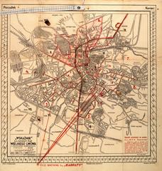
This map of Lviv was printed in 1937 as an appendix to the “Illustrated Guidebook of Lviv. Third edition” (Ilustrowany przewodnik po Lwowu z planem. Wydanie III zmienione i uzupełnione. 1937).
Legend:
In the lower left corner is the name: “Map of Greater Lviv” (Plan Wielkiego Lwowa).
Beneath the name in red ink is information on who commissioned the map, their address and telephone number: “Gazeta Mieshkaniowa in Lviv” (Nakład "Gazety Mieszkaniowej" we Lwowie, Pasaż Hausmana 7. telefon 107-90).
In the lower left corner is also information on the illustrator: “Drawn by E. Lan” (Rys. E. Lan).
In the lower right corner is a list of the 130 objects identified on the map.
Below the list is the location and date the map was published: “Lviv, June 1937” (Lwów VI.37).
Along the right edge of the map are advertisements.