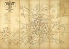
This plan shows the city’s reconstruction in the 18th century; it was created by Maurycy Hr. Dzieduszycki.
Legend:
In the upper left corner is information about the author and the name: “Map of Lviv in the 18th century to 1775” (Plan Lwowa, jakim był w XVIII wieku do roku 1775 skreslil Maurycy Hr. Dzieduszycki).
In the lower left corner is the city’s crest, information about where the map was printed and the year of publication: “Lithography by T. K. Galician Government Printers, 1858.” (Litogr. w c.k. galicyjskiej drukarna rządowej 1858).
In the upper right corner is a list of 75 objects identified on the map (Objaśnienia).
In the lower right corner is information about where the map was published: “Addition to the weekly Gazeta Lvovska” (Dodatek tygodniowy przy Gazecie Lwowskiej z roku 1858).