General Plan (Zaleszczyk)
- ID: 34509
- Place: Zalishchyky


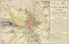
This hand-drawn map of Lviv provides a schematic demonstration of the city and its environs.
The map's author was Adalbert Karasek. The plan provides 1807 as its date.
A peculiarity of the map is the fact that it demonstrates fragments of F. Getkant's mid-seventeenth century fortifications in the territory of the Brody suburb [12], p. 223
Legend:
Map characterization:
Map's toponymics:
Inconsistencies and inaccuracies on the map:
City characterization:
The map of Lviv provides a schematic outline of the urban environment characteristic of the late nineteenth and early twentieth centuries. Attention is given more to the artistic execution of the map, than its relevance to actual historical reality.
The map is one of the few to show fragments of defensive constructions by F. Getkant.
From a description of the city by Chodynicki, we can learn, that illumination of the city streets began in 1801. The next decade saw the start of paving the streets and roads, and their further maintenance [9], p. 443-444.
The city's population as of 1808 comprised 44,655 people, including 41,493 city residents, and 3,162 arrivals. A decrease in city population is evident in the early 1800s, due to epidemics [19], p. 35, 113; [9] p. 461.
As of 1808, the city had about 2,515 buildings. The census of 1810 enumerates 2,454 buildings in the city [9] p. 461; [19], p. 30.
Entry by: Serhiy Tereshchenko Translated by: Pavlo Hrytsak